India has taken a significant leap in atmospheric science and environmental monitoring with the successful completion of first field trials of a custom high-altitude drone developed by the National Institute of Ocean Technology (NIOT). This achievement, accomplished under the ambitious Mission Mausam, represents a major advancement in the country’s ability to gather real-time, high-resolution data for weather forecasting, air pollution tracking, and climate research. As India faces increasing challenges from extreme weather events, urban pollution, and climate variability, such indigenous technological innovations are becoming vital tools for building a more resilient and informed nation.
Mission Mausam, launched by the Ministry of Earth Sciences (MoES), aims to transform India into a “weather-ready and climate-smart” nation. The multi-year programme focuses on enhancing observational networks, improving forecast accuracy through advanced modelling and artificial intelligence, and delivering actionable weather and climate services across sectors such as agriculture, disaster management, aviation, and public health. The development and testing of this high-altitude drone align perfectly with the mission’s core objective of expanding in-situ and remote sensing capabilities for better atmospheric understanding.
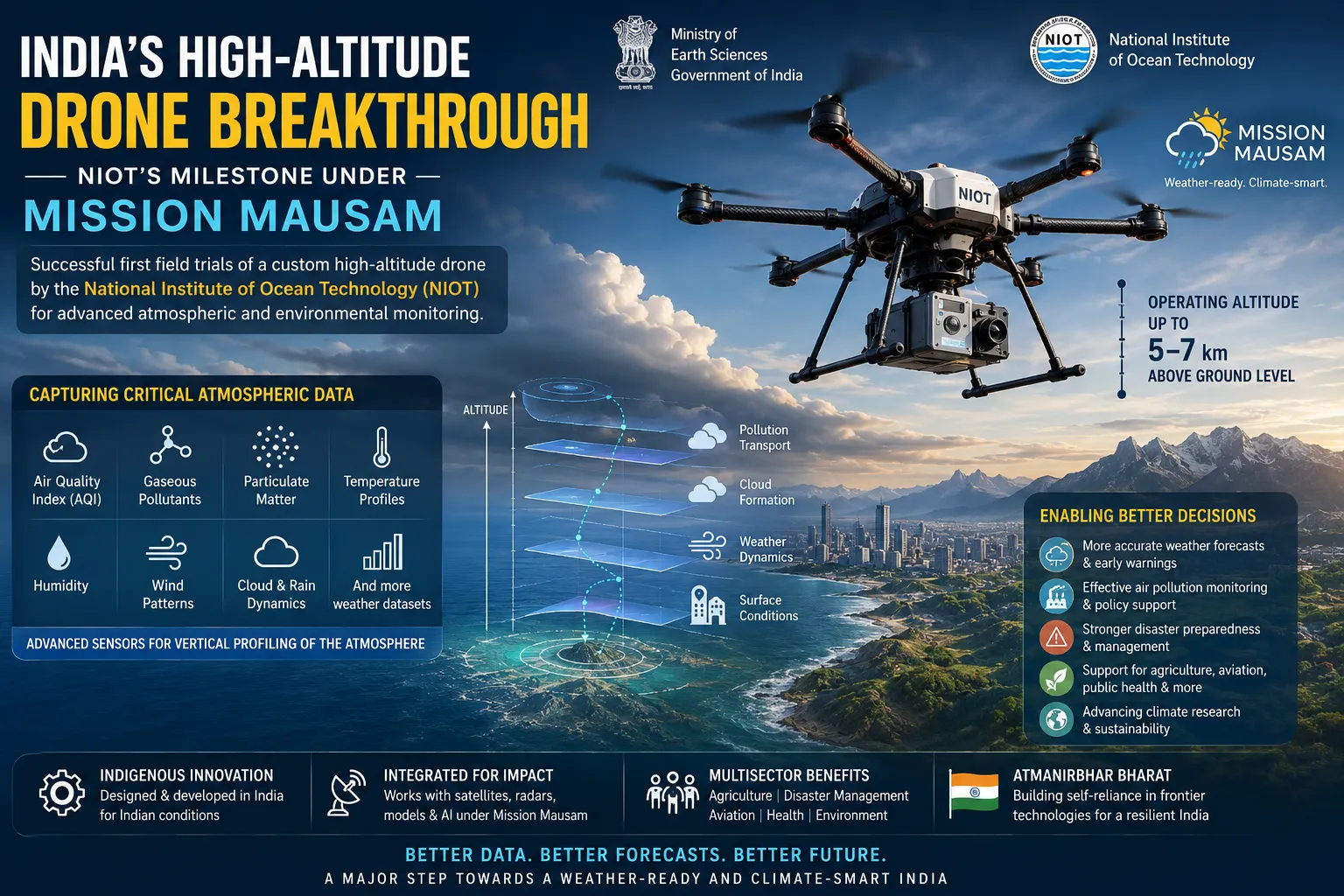
The High-Altitude Drone: Design and Capabilities
NIOT’s custom high-altitude drone has been engineered specifically for challenging atmospheric conditions. Unlike conventional drones limited to lower altitudes, this platform is designed to operate effectively at several kilometres above ground level, collecting critical meteorological and environmental data that ground-based stations or traditional methods often miss. During its inaugural field trials, the drone successfully captured key parameters including Air Quality Index (AQI) readings, levels of various gaseous pollutants, particulate matter, temperature profiles, humidity, wind patterns, and other weather datasets essential for comprehensive atmospheric analysis.
The integration of advanced sensors allows the drone to provide vertical profiling of the atmosphere — data that is particularly valuable for understanding pollution dispersion, cloud formation, and the dynamics influencing rainfall and storms. This capability addresses long-standing gaps in India’s observational infrastructure, where data scarcity at higher altitudes has limited the precision of numerical weather prediction models.
Significance for Weather Forecasting and Pollution Monitoring
Accurate weather forecasting in a country as geographically diverse as India remains a complex task. Monsoons, cyclones, heatwaves, and localized thunderstorms demand hyper-local and vertically resolved data. The high-altitude drone contributes by offering real-time inputs that can significantly improve short- to medium-range forecasts. Better prediction of rainfall intensity, storm paths, and temperature variations can translate into more effective early warning systems, potentially saving lives and reducing economic losses during extreme events.
On the pollution front, the drone’s ability to measure air quality at different altitudes is especially relevant for Indian cities grappling with severe smog episodes. Traditional monitoring stations primarily capture ground-level data, but pollutants often concentrate or behave differently at higher elevations. Vertical profiling helps scientists understand inversion layers, pollutant transport, and the effectiveness of mitigation measures. This information is crucial for framing targeted policies in urban centres and industrial zones.
Furthermore, the data gathered supports broader climate research. By studying air-sea interactions, aerosol distribution, and atmospheric composition, researchers can gain deeper insights into long-term climate patterns and the impacts of global warming on the Indian subcontinent. This aligns with India’s commitments under international climate frameworks and its domestic goals for sustainable development.
NIOT’s Role and Indigenous Innovation
The National Institute of Ocean Technology, based in Chennai, has emerged as a key player in Mission Mausam. Traditionally focused on ocean sciences and marine technology, NIOT has expanded its expertise into atmospheric and met-ocean applications. The high-altitude drone project showcases the institute’s growing capabilities in designing custom unmanned systems tailored to Indian conditions — from coastal environments to high-altitude operations.
Developing such technology indigenously reduces dependence on imported platforms and sensors while allowing customization for local requirements, such as handling monsoon winds, dust storms, or high humidity. The successful trials validate the robustness of the system and pave the way for expanded deployment, potentially integrating with other Mission Mausam initiatives like enhanced radar networks, new satellites, and high-performance computing facilities.
Broader Impact on Science, Economy, and Society
The deployment of high-altitude drones under Mission Mausam carries multifaceted benefits. For agriculture, more accurate forecasts can help farmers optimize planting, irrigation, and harvesting schedules, minimizing crop losses. In disaster management, improved data can strengthen preparedness for cyclones and heavy rainfall events that have become more frequent. Aviation authorities can benefit from better turbulence and visibility predictions, while public health agencies can use pollution data for timely advisories.
Economically, investing in such technologies boosts India’s growing drone ecosystem and creates opportunities for skilled jobs in aerospace, data analytics, and environmental science. It also positions the country as a contributor to global meteorological advancements, especially in tropical weather research where India has unique expertise.
From a strategic perspective, strengthening atmospheric monitoring supports national security and infrastructure planning. Better understanding of extreme weather helps protect critical assets, including coastal regions, hydropower projects, and urban centres.
Challenges and the Road Ahead
While the first field trials mark an encouraging start, several challenges remain. Operating drones reliably at high altitudes requires overcoming issues related to battery endurance, sensor accuracy in extreme conditions, data transmission, and regulatory frameworks for beyond-visual-line-of-sight flights. Ensuring data quality, integration with existing models, and scaling operations across diverse Indian terrains will demand continued research and collaboration between NIOT, the India Meteorological Department (IMD), other scientific institutions, and private sector partners.
Future plans under Mission Mausam may include deploying multiple such drones, integrating them with AI-driven analytics, and combining drone data with satellite observations for a more complete Earth system picture. Long-term success will also depend on building a skilled workforce capable of operating and maintaining these advanced systems.
A Step Towards Atmanirbhar Bharat in Science
NIOT’s high-altitude drone trial under Mission Mausam exemplifies India’s push for self-reliance in frontier technologies. It demonstrates how focused government missions, combined with institutional excellence, can yield practical solutions to pressing national challenges.
As climate change intensifies and the need for precise environmental intelligence grows, tools like this drone will become indispensable. By investing in such innovations today, India is not only enhancing its weather and climate services but also building scientific capacity that will serve generations to come.
The successful first trials open an exciting chapter in India’s atmospheric science journey. With sustained momentum, Mission Mausam and initiatives like NIOT’s drone programme have the potential to significantly elevate the nation’s resilience against weather and climate uncertainties while contributing valuable knowledge to the global scientific community.
presslyy presslyy presslyy presslyy presslyy presslyy presslyy presslyy presslyy presslyy presslyy presslyy presslyy presslyy presslyy presslyy presslyy presslyy presslyy presslyy presslyy presslyy presslyy presslyy presslyy presslyy presslyy presslyy presslyy presslyy presslyy presslyy presslyy presslyy presslyy presslyy presslyy presslyy presslyy presslyy presslyy presslyy presslyy presslyy presslyy presslyy presslyy presslyy presslyy presslyy presslyy presslyy presslyy presslyy presslyy presslyy presslyy presslyy presslyy presslyy presslyy presslyy presslyy presslyy presslyy presslyy presslyy presslyy presslyy presslyy presslyy presslyy presslyy presslyy presslyy presslyy presslyy presslyy presslyy presslyy presslyy presslyy presslyy presslyy presslyy presslyy presslyy presslyy presslyy presslyy presslyy presslyy presslyy presslyy presslyy presslyy presslyy presslyy presslyy presslyy presslyy presslyy presslyy presslyy presslyy presslyy presslyy presslyy presslyy presslyy presslyy presslyy presslyy presslyy presslyy presslyy presslyy presslyy presslyy presslyy presslyy presslyy presslyy presslyy presslyy presslyy presslyy presslyy presslyy presslyy presslyy presslyy presslyy presslyy presslyy presslyy presslyy presslyy presslyy presslyy presslyy presslyy presslyy presslyy presslyy presslyy presslyy presslyy presslyy presslyy presslyy presslyy presslyy presslyy presslyy presslyy presslyy presslyy presslyy presslyy presslyy presslyy presslyy presslyy presslyy presslyy presslyy